Altimeter Temperature Correction Tool is now available online.
What is it for
When vectoring or straightening by using the air traffic service (ATS) surveillance system, including at the request of the pilot, the controller must ensure the flight not lower than the surveillance minimum altitudes (SMAA). These altitudes must be corrected by the ATM (Air Traffic Management) authority due to the influence of low temperatures.
For practical use in QNH and foot altitude measurement
conditions, it is required to find the temperature range at which altimeter temperature corrections for minimum altitudes will be applied in 100-feet increment, which corresponds to the minimum resolution of the RBS aircraft transponder altitude data transmission.
How it works
In order to calculate the range of maximum and minimum aerodrome temperatures in degrees Celsius in which certain temperature corrections will be applied, the user should do the following:
- Enter the lowest threshold elevation of runway in feet in the Elevation text box
- Enter in the Altitudes text box published minimum altitudes (SMAA) in feet, separated with a space
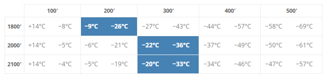
- Enter in the Temperature text box the current temperature in degrees Celsius, to highlight the range in the results table
- Press the Calculate button
The results
The entered data is checked in accordance with the following criteria — the lowest threshold elevation of runway and minimum altitudes must be numeric and above zero. If the result of the check is negative, the user is informed about the error. Calculation will not be done.
If the user input validation is successful – as the result of the calculation the range of minimum and maximum temperatures will be calculated for altitude correction with 100-feet increment. The result of the calculation is shown in the table. The temperature value for temperatures below -75°C is not displayed.
Feedback
Please, feel free to leave a comment here, or on the community page.